Urban nature & Outdoor spaces
Toronto’s relationship with nature exists in constant negotiation. Squeezed between the vast expanse of Lake Ontario and an ever-expanding urban grid, the city has cultivated a unique network of outdoor spaces that serve millions of residents and visitors annually. From the sandy stretches of the waterfront to the cherry blossom canopies of High Park, these green and blue spaces offer far more than scenic backdrops—they function as essential infrastructure for physical health, mental wellbeing, and ecological balance.
Navigating these spaces effectively requires understanding their distinct rhythms, regulations, and seasonal transformations. Water quality monitoring, cycling infrastructure debates, cherry blossom crowds, and wildlife migration patterns all demand specific knowledge. This comprehensive resource introduces the fundamental aspects of Toronto’s urban nature network, providing the context needed to make informed decisions about when, where, and how to engage with the city’s outdoor environments safely and respectfully.
The Toronto Waterfront: Where Lake Ontario Meets Urban Life
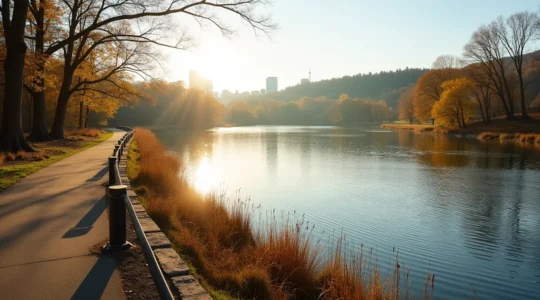
The Toronto waterfront stretches approximately 46 kilometers along Lake Ontario’s northwestern shore, representing one of the city’s most valuable natural assets. This linear park system connects distinct beach communities, naturalized shorelines, and recreational zones that see dramatically different usage patterns throughout the year.
Understanding Water Quality and Safety Protocols
Toronto Public Health monitors eleven designated beaches daily during swimming season, typically from late June through early September. E. coli levels fluctuate based on rainfall, temperature, and wave action—heavy storms can push urban runoff into the lake, triggering temporary beach closures within 24-48 hours. The Blue Flag certification program, administered internationally, designates beaches meeting strict environmental and safety standards, providing a reliable quality indicator for visitors unfamiliar with local conditions.
Selecting Beaches Based on Activity and Atmosphere
Each waterfront zone attracts different communities and supports different activities. Woodbine Beach offers volleyball courts and extensive sandy areas ideal for families, while Cherry Beach’s eastern location and protective breakwaters create calmer waters preferred by paddleboarders. Hanlan’s Point on the Toronto Islands maintains clothing-optional sections, attracting a specific adult demographic. Understanding these distinct characteristics helps visitors avoid mismatched expectations and potential discomfort.
Seasonal Hazards and Timing Considerations
Spring ice breakup can leave sharp chunks along shorelines through late April. Summer brings harmful algal blooms during extended heat periods, creating green surface scum that releases toxins dangerous to children and pets. Autumn’s dramatic light conditions make sunset photography spectacular between 6:00-7:30 PM in October, but rapidly cooling temperatures after dark catch unprepared visitors off guard. Winter transforms the waterfront into a windswept environment where frostbite risk becomes serious within fifteen minutes of exposed skin contact.
Cycling Through the City: Infrastructure and Ongoing Evolution
Toronto’s cycling infrastructure remains a work in progress, characterized by fragmented networks and ongoing political debates. Unlike European cities with decades of established cycling culture, Toronto added most of its 525 kilometers of bike routes within the past fifteen years, creating a patchwork system that requires strategic navigation.
The Reality of Protected Versus Painted Infrastructure
Understanding the difference between infrastructure types directly impacts safety decisions. Painted bike lanes offer no physical protection from vehicle traffic—they’re essentially painted suggestions that disappear under snow or during construction. Protected lanes use concrete curbs or flexible posts to create separated corridors, reducing collision risk by approximately 90 percent according to transportation studies. The Bloor Street corridor, Richmond-Adelaide loop, and Harbourfront trail represent the city’s most developed protected networks.
Bike Share Systems and Theft Prevention
Bike Share Toronto operates over 6,850 bikes at 625 stations, primarily concentrated south of Bloor Street. The system functions well for point-to-point trips under thirty minutes but becomes expensive for longer recreational rides due to overage charges. Personal bike ownership introduces theft concerns—Toronto consistently ranks among Canadian cities with highest bike theft rates. U-locks securing both frame and wheels to fixed objects remain essential, with additional precautions like removing seats and accessories necessary in high-risk areas near transit stations and university campuses.
Winter Cycling and Seasonal Extension
The cycling season traditionally collapsed each November, but dedicated year-round riders have normalized winter cycling in recent years. The city now maintains approximately 100 kilometers of priority cycling routes during winter months, though ice accumulation, reduced daylight, and driver visibility challenges require significant equipment adaptations. Studded tires, powerful lighting systems, and layered clothing become non-negotiable rather than optional accessories.
Public Squares and Civic Gathering Spaces
Toronto’s public squares function as outdoor living rooms, hosting everything from professional concerts to impromptu skating sessions. Nathan Phillips Square in front of City Hall represents the most iconic civic space, while Yonge-Dundas Square provides a more commercial atmosphere modeled after Times Square. These spaces operate under specific regulations that surprise visitors expecting complete freedom in public areas.
Alcohol consumption remains prohibited in all Toronto parks and squares without special event permits, despite widespread usage in residential backyards. Amplified sound requires advance permissions. Commercial photography and filming face restrictions designed to prevent disruption and protect privacy. During major demonstrations or celebrations, crowd dynamics can shift rapidly—the post-playoff celebrations following Raptors’ victory turned chaotic when crowds exceeded two million people, illustrating how seemingly festive gatherings can become unsafe pressure situations.
Free amenities include public washrooms, water fountains, WiFi in select locations, and seasonal programming. The Nathan Phillips Square skating rink operates from late November through March, weather permitting, offering completely free ice time during one of the city’s most photogenic winter experiences. Arriving before 10:00 AM on weekends avoids the dense afternoon crowds that make recreational skating nearly impossible.
The Toronto Islands: A Car-Free Natural Retreat
The Toronto Islands archipelago sits just 1.3 kilometers offshore but feels worlds away from the urban mainland. This 230-hectare green space operates under unique rules reflecting its dual nature as recreational destination and residential community—approximately 650 people live year-round in one of Canada’s most unusual neighborhoods.
Ferry access through Toronto Parks, Forestry and Recreation represents the primary public transportation method, with three terminals serving different island destinations. Centre Island ferries attract family crowds heading to Centreville Amusement Park. Ward’s Island provides the quietest, most naturalized experience. Hanlan’s Point offers beach access and connections to Billy Bishop Airport. Water taxi services operate privately at premium prices but provide flexibility during peak times when ferry lineups exceed ninety-minute waits.
The critical logistical challenge involves last ferry departure times. Missing the final sailing—typically between 10:00-11:30 PM depending on season and day—means either expensive water taxi fees or potentially spending an unplanned night outdoors, as no overnight camping facilities exist for the general public. Seasonal attractions like the disc golf course, rental facilities, and food vendors operate on variable schedules, with most closing by early October.
The vehicle ban, implemented to preserve the pedestrian character and protect residential tranquility, extends to all private cars. Bicycles, wheelchairs, and service vehicles provide the only wheeled transportation, creating an unusually quiet soundscape dominated by waves, birds, and human voices rather than engine noise.
Urban Parks and Green Corridors: Ecological Preservation in Practice
Toronto maintains over 1,500 parks ranging from pocket gardens to wilderness-scale ravines. High Park’s 161 hectares represent the largest developed park, while the ravine system—carved by the Don River, Humber River, and numerous creeks—creates approximately 300 kilometers of continuous green corridors threading through otherwise dense neighborhoods.
These spaces balance competing demands: recreational access versus ecological preservation, manicured landscapes versus naturalized habitats, public safety versus wildlife corridors. Think of Toronto’s parks as a spectrum—Nathan Phillips Square occupies the fully designed, human-centered end, while sections of Rouge National Urban Park represent the wild, ecosystem-prioritized opposite.
Navigating Seasonal Highlights and Natural Hazards
Fall foliage peaks typically between mid-October and early November, with High Park’s oak savannah and the Humber Valley’s sugar maples offering spectacular color displays. Spring brings migrating warblers through the ravines, creating internationally recognized birding opportunities at locations like Tommy Thompson Park. Summer introduces blacklegged tick populations in tall grass areas—these vectors for Lyme disease require protective clothing and post-hike body checks, particularly in less-maintained ravine sections.
Accessing Specialized Facilities Responsibly
The Toronto Zoo, located within Rouge Park, charges admission fees that support conservation programs but create access barriers. Annual passes become cost-effective for families planning three or more visits. The zoo’s public transit connections remain limited, making car access nearly essential despite the park system’s general emphasis on alternative transportation.
The Cherry Blossom Phenomenon: Timing, Crowds and Tree Protection
High Park’s cherry blossom trees, gifted by Japan in 1959, trigger an annual pilgrimage that has intensified dramatically with social media’s influence. The blooms last approximately five to seven days at peak intensity, creating extreme crowding pressure within an exceptionally narrow window.
Peak bloom timing varies by up to three weeks year-over-year, depending on spring temperature patterns. Warm March weather can trigger early April blooms, while cool springs push peak viewing into early May. The city’s official “Sakura Watch” updates provide daily bloom progress reports, but predicting the exact peak remains imprecise—buds can advance from closed to fully open within 48 hours during warm spells.
Alternative viewing locations include Trinity Bellwoods Park, Philosophers’ Walk near the University of Toronto, and residential streets in the Beaches neighborhood. These sites offer smaller concentrations of trees but dramatically reduced crowds, allowing actually peaceful contemplation rather than navigating shoulder-to-shoulder masses.
Tree protection has become critical as visitor numbers overwhelm the grove. Root compaction from foot traffic, branch damage from climbing and pulling for photographs, and bark injuries from carving or leaning damage the aging trees’ health. The city has implemented temporary fencing and vehicle restrictions during peak bloom to prevent irreversible ecological damage to these culturally significant specimens.
Urban Wildlife and Water Bodies: Regulations Governing Natural Interactions
Toronto’s position along the Lake Ontario shoreline and within major migratory flyways creates surprising wildlife diversity. Coyotes inhabit the ravines, great blue herons fish the waterfront, and migratory waterfowl use Toronto’s wetlands as staging areas during spring and fall journeys.
Fishing in Toronto’s urban water bodies requires valid Ontario fishing licenses, available through the provincial government’s online system or authorized retailers. Different regulations apply to Lake Ontario versus inland creeks—minimum size limits, catch limits, and seasonal closures vary by species and location. Many urban anglers remain unaware that even catch-and-release fishing in prohibited areas or without proper licensing carries significant fines.
Winter skating on natural ice requires understanding unofficial practice versus legal permission. While the city maintains official ice rinks, natural water bodies like Grenadier Pond in High Park attract skaters during sustained cold periods. The city actively discourages this practice, posting no-skating signs and refusing to monitor ice thickness, making it an entirely at-your-own-risk activity with potential legal liability.
Wildlife viewing opportunities peak during migration events—May brings the spring warbler migration through the ravines, while November concentrations of waterfowl gather at the Leslie Street Spit. Maintaining respectful distances prevents stress to animals and ecosystem disruption. Feeding wildlife, particularly common with ducks and geese, creates dependency, spreads disease, and attracts rats to parks—it’s prohibited but remains widespread due to inadequate enforcement.
Toronto’s urban nature network represents far more than recreational amenity—it functions as essential infrastructure supporting biodiversity, managing stormwater, moderating temperature extremes, and providing psychological respite from urban intensity. Engaging with these spaces effectively requires understanding their specific rhythms, respecting their ecological limits, and recognizing that urban nature exists through active management rather than pristine wilderness. Whether you’re planning waterfront cycling routes, timing cherry blossom visits, or exploring ravine trails, informed preparation transforms these experiences from potentially frustrating to genuinely restorative.
A Conservation Officer’s Guide: How to Fish and Recreate Safely at Grenadier Pond
True safety at Grenadier Pond comes not just from following rules, but from understanding the fragile urban ecosystem you are a part of. Ice is officially monitored and rarely safe; hidden dangers like shelf ice exist even when it looks…
Read more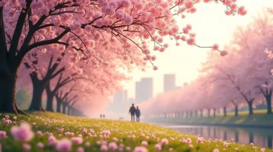
How to See the Cherry Blossoms Without Destroying the Trees?
To truly honour Toronto’s cherry blossoms, we must shift our perspective from being a mere spectator to an active steward of their fragile health. The intense crowds and common behaviours like climbing or shaking branches cause severe, often irreversible, stress…
Read more
Your Guide to Enjoying High Park Without Harming Its Fragile Ecosystem
The key to enjoying High Park is shifting from a passive visitor to an active steward of its globally rare ecosystem. Common park activities, like off-trail walking or casual picnics, have a disproportionately negative impact due to the park’s fragile…
Read more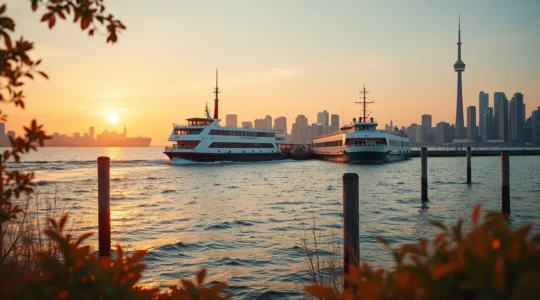
How to Navigate Toronto Islands Logistics for a Stress-Free Day?
The key to a stress-free Toronto Islands trip isn’t just knowing what to do; it’s understanding the logistical traps that ruin the day for thousands of visitors. Ferry lines can easily exceed two hours on summer weekends, but a simple…
Read more
Beyond the Events: A Torontonian’s Guide to Using Public Squares Year-Round
Toronto’s public squares are more than just postcard settings; they are complex civic ecosystems with their own rules and rhythms. To truly make the most of them, you need to move beyond the event calendar and master the practical logistics—from…
Read more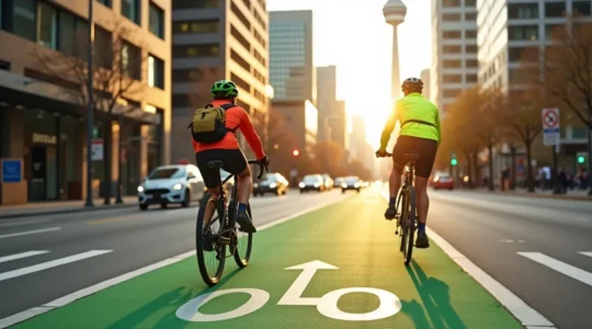
How to Bike Commute in Toronto and Actually Feel Safe
In summary: True safety in Toronto requires “infrastructure literacy”—learning to read the unwritten rules of specific streets, not just following generic advice. Mastering tactical skills for dealing with streetcars, channelling your route, and securing your bike are non-negotiable for urban…
Read more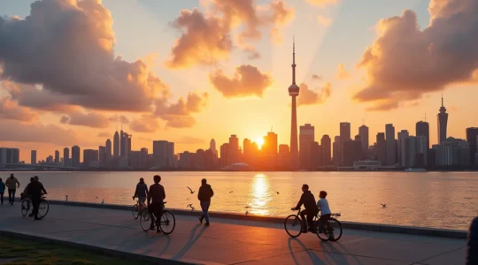
How to Safely Enjoy Toronto’s Waterfront Without Sacrificing the Fun
The common wisdom is that checking the city’s website is enough to know if Toronto’s water is safe. The reality is, by the time you read that green flag status, the data is already 24 hours old. Heavy rainfall can…
Read more