
The common wisdom is that checking the city’s website is enough to know if Toronto’s water is safe. The reality is, by the time you read that green flag status, the data is already 24 hours old.
- Heavy rainfall can make every single beach unsafe overnight due to sewer overflows, a fact often missed by casual beachgoers.
- Mastering waterfront logistics—like choosing between a 2-hour ferry line and a pricier water taxi—is just as important as checking water quality for a stress-free day.
Recommendation: Learn to read the water’s visual cues for yourself and plan your trip around the lake’s predictable rhythms, not just a day-old website update.
Living in Toronto, you know the feeling. The heat radiates off the pavement, the air is thick, and the deep blue of Lake Ontario calls out like a siren. For active residents and families, the waterfront is our backyard, our escape. But as you pack the cooler and towels, a familiar question pops into your head, maybe even texted from a friend: “Is the water actually safe today?” You’ve heard the stories of beach closures and seen the headlines, leaving you to wonder if that refreshing dip is worth the risk.
The standard advice is simple: check the city’s SwimSafe website. And you should. But as someone who’s spent countless seasons on duty at The Beaches, I can tell you that’s only half the story. Relying solely on that green icon is like driving while only looking in the rearview mirror. The real key to enjoying our lake with confidence isn’t just about following rules; it’s about understanding the rhythm of the water and the city itself. It’s about learning to read the subtle signs the lake gives you in real-time.
So, forget the simple yes or no. The truth is far more interesting. What if you could know *why* the beaches close, and predict when it’s most likely to happen? What if you could navigate the logistical hurdles of the Islands like a seasoned local, or know which patch of shoreline perfectly matches your vibe for the day? This guide is built on that insider knowledge. We’re going beyond the basic warnings to give you the practical, on-the-ground strategies to manage water safety and plan the perfect, worry-free day on our incredible urban waterfront.
This article will break down everything you need to know, from the science behind beach closures to the practicalities of planning a budget-friendly day out. We’ll explore which beaches suit different lifestyles and how to master the logistics of a trip to the Toronto Islands.
Summary: Your Complete Guide to Safely Navigating Toronto’s Waterfront
- Why Do Toronto Beaches Often Close for Swimming in Summer?
- How to Plan a Full Day at the Waterfront for Under $50 CAD?
- Woodbine vs. Bluffer’s Park: Which Beach Fits Your Lifestyle?
- The Winter Shoreline Mistake That Endangers Walkers Every Year
- When to Catch the Best Skyline Sunset from the Islands?
- Hanlan’s Point vs. Centre Island: Which Beach Fits Your Comfort Level?
- High Park vs. Trinity Bellwoods: Which Park Is Better for Picnics?
- How to Navigate Toronto Islands Logistics for a Stress-Free Day?
Why Do Toronto Beaches Often Close for Swimming in Summer?
The number one question I get is why a beautiful, sunny day can still mean a red flag at the beach. The answer isn’t pollution in the general sense; it’s about specific events, primarily heavy rainfall. Toronto has an older system of Combined Sewer Overflows (CSOs) in some parts of the city. When a major storm hits, this system can get overwhelmed, releasing a mix of stormwater and untreated sewage directly into the lake. This causes a spike in E. coli bacteria levels, which is the main health concern.
To its credit, Toronto is very strict about safety. The city’s threshold for closing a beach is when tests show more than 100 E.coli per 100 millilitres of water, a much tougher standard than the national guideline of 200. The challenge for you, the beachgoer, is what I call the “24-hour lag.” The water samples are collected daily, but the lab results aren’t available until the next day. This means the green flag you see today is based on yesterday’s water. If there was a big storm overnight, that flag is dangerously out of date.
A stark reminder of this was the intense rainstorm in mid-July 2024. Following the deluge, the city’s CSO system was completely overwhelmed. As a result, every single beach in Toronto was flagged as unsafe for swimming. This wasn’t an isolated issue; it showed how one major weather event can impact the entire waterfront, demonstrating the direct link between rainfall and water quality. This is why learning to read the water yourself is a non-negotiable skill for any Toronto lake lover.
Your Lifeguard-Approved Beach Safety Checklist
- Check the official source: Start with the City of Toronto’s SwimSafe map for the daily status. This is your baseline.
- Factor in the 24-hour lag: Did it rain heavily in the last 24-48 hours? If yes, approach any beach with extra caution, regardless of the flag colour.
- Read the water: Look for visual cues. Is the water unusually cloudy, murky, or full of debris? Clear water is a much better sign. Trust your eyes.
- Know your beach’s certification: Check if your destination is a Blue Flag beach. This international eco-certification indicates consistent high quality and safety standards.
- Consider the location: Beaches further from the mouths of the Don or Humber rivers and known CSOs tend to recover more quickly after a storm.
How to Plan a Full Day at the Waterfront for Under $50 CAD?
A fantastic day exploring Toronto’s waterfront doesn’t need to break the bank. With a little planning, you can easily have a full, memorable experience for less than $50 per person. The key is to focus your spending on the experience, not just the logistics. Your biggest variable will always be how you get across the harbour to the Islands, but even getting to the docks can be done economically.
Your first smart move is navigating the city itself. Instead of driving and paying for expensive waterfront parking, embrace the TTC. A TTC day pass sold as a PRESTO ticket costs $13.50 and gives you unlimited travel on the streetcar, subway, and bus systems all day. You can take the 509 or 510 streetcar right to the Jack Layton Ferry Terminal, making the journey part of the adventure.
Once you’re at the harbour, you face the classic Toronto choice: the public ferry or a private water taxi? This is the ultimate logistical trade-off between time and money. The ferry is significantly cheaper, but on a beautiful summer weekend, the lineup can easily be an hour or two each way. The water taxi is faster and more direct but will eat up a larger chunk of your budget. For a truly budget-conscious day, packing your own picnic and drinks is essential, saving you from marked-up island prices and leaving more room in your budget for the fun.
Here’s a breakdown of your main transportation choices to help you decide where to spend your money. This table doesn’t even include the cost of waiting in line with impatient kids!
| Transportation Option | Cost (One Way) | Travel Time | Pros | Cons |
|---|---|---|---|---|
| Public Ferry | $9.11 (adult) | 13-15 minutes | Cheapest option, scenic ride | Long wait times on weekends (1-2 hours) |
| Water Taxi | $13-15 | 5 minutes | No waiting, flexible timing | Higher cost, cash includes tax |
| TTC Day Pass | $13.50 | All day | Unlimited travel on subway/bus/streetcar | Doesn’t include ferry |
Woodbine vs. Bluffer’s Park: Which Beach Fits Your Lifestyle?
Not all Toronto beaches are created equal. Two of the city’s most beloved spots, Woodbine Beach and Bluffer’s Park Beach, offer dramatically different experiences, even though they both sit on the eastern shoreline. Choosing the right one depends entirely on the kind of day you’re looking for: social energy or natural grandeur. The good news is that both are typically among the 7 of Toronto’s beaches that have Blue Flag eco-certification, meaning they consistently meet high standards for water quality and management.
Woodbine Beach is for the active and social. It’s the city’s playground. Think long stretches of sandy shoreline dotted with dozens of beach volleyball courts, a bustling boardwalk perfect for cycling or rollerblading, and accessible beach mats making it easier for everyone to get to the water. The vibe is energetic, loud, and full of life. It’s the place to see and be seen, to join a pickup game, or to simply people-watch from your towel. It’s incredibly accessible via the Queen Street streetcar, making it a default choice for many.
Bluffer’s Park, on the other hand, is for the nature lover seeking awe. The beach itself is smaller, but the main attraction is the majestic Scarborough Bluffs that tower over the shoreline. The experience here is about soaking in the dramatic scenery, exploring the trails, and finding a more secluded spot to relax. It feels more like an escape from the city than a part of it. The trade-off is accessibility; it’s more of a destination you need to drive or cycle to, and the pathways can be steep. It’s for those who want their beach day to come with a side of epic views and a quieter atmosphere.

As you can see, the choice is clear. If your ideal day involves a frisbee, a crowd, and easy access to a snack bar, Woodbine is your spot. If you’d rather be surrounded by towering cliffs and the sounds of nature, make the trip to Bluffer’s Park. Both offer a fantastic, safe way to enjoy the lake, just with completely different personalities.
The Winter Shoreline Mistake That Endangers Walkers Every Year
Our waterfront is a year-round destination, but as a lifeguard, my biggest safety concern shifts dramatically when the temperature drops. The most dangerous mistake we see people make in winter isn’t about swimming; it’s about walking. Specifically, it’s the fatal misjudgment of walking on what appears to be a solid extension of the shoreline. This is known as the “shelf ice illusion.”
Shelf ice forms when spray and waves freeze along the edge of the lake. Snow then covers it, creating a smooth, white plain that looks like a stable, frozen beach. It appears solid. It looks safe. But it’s a trap. Underneath that fragile crust is nothing but frigid, turbulent Lake Ontario water. It is not connected to the lakebed and can break away without any warning whatsoever.
Every year, we see footprints leading out onto these shelves, and it sends a shiver down our spine. People, often with dogs or children, venture out for a photo or a closer look, completely unaware that they are standing on a thin layer of ice over deadly cold water. A collapse is instantaneous, and the shock of the icy water can incapacitate even a strong person in seconds. As the Toronto Fire Services constantly warns, this is a life-threatening risk.
Shelf ice creates a fragile crust of ice and snow over the frigid water that appears solid but can collapse without warning.
– Toronto Fire Services, Winter Safety Advisory – Great Lakes Shelf Ice
The only safe way to enjoy the winter shoreline is to stay on the designated paths, boardwalks, and sandy or rocky areas that are clearly part of the land. No photo is worth your life. Remember this: if you can’t tell for certain what is land and what might be ice, assume it is not safe. The shelf ice illusion is one of the most deceptive dangers on the Great Lakes, and respecting it is non-negotiable.
When to Catch the Best Skyline Sunset from the Islands?
A Toronto Island sunset is a rite of passage. Watching the sun dip behind the iconic skyline, setting the glass towers ablaze with colour, is a truly magical experience. But catching the perfect one requires more than just showing up at dusk. It’s a game of timing, location, and logistics. For photographers and romantics alike, the key is to position yourself for an unobstructed view and give yourself enough time to get there.
While any spot facing the city can be beautiful, the prime location for that postcard-perfect shot is the Centre Island Pier. Located at Centre Island Beach, it extends out into the harbour, offering a clean, direct sightline to the entire downtown core, from the CN Tower to the financial district. It gets you away from the trees and crowds, allowing for a panoramic view that is simply unmatched. Another fantastic, and often quieter, option is the boardwalk that runs from Ward’s Island towards Centre Island. This elevated path offers layered compositions, with views of Tommy Thompson Park in the foreground adding depth to your skyline shot.
The biggest mistake people make is underestimating the time it takes to get into position. The Toronto Islands are bigger than most people think; the main park is a sprawling 560 acres. The walk from the Ward’s Island ferry dock to the Hanlan’s Point ferry dock at the other end is roughly 5 kilometers from Ward’s Island to Hanlan’s Point. If you take the Ward’s Island ferry, you need to budget a good 25-30 minute walk just to get to the Centre Island Pier. Always check the sunset time before you go, and plan to be at your chosen spot at least 30 minutes prior to capture the full range of changing light. This means factoring in ferry schedules, potential queues, and walking time to ensure you’re not rushing at the golden hour.
Hanlan’s Point vs. Centre Island: Which Beach Fits Your Comfort Level?
The Toronto Islands offer a spectrum of beach experiences, and nowhere is this more apparent than in the contrast between Hanlan’s Point and Centre Island. Choosing between them is less about water quality and more about social atmosphere and your personal comfort level. Both provide a wonderful escape, but they cater to very different mindsets and groups. It’s essential to know what to expect to ensure your beach day is relaxing and enjoyable.
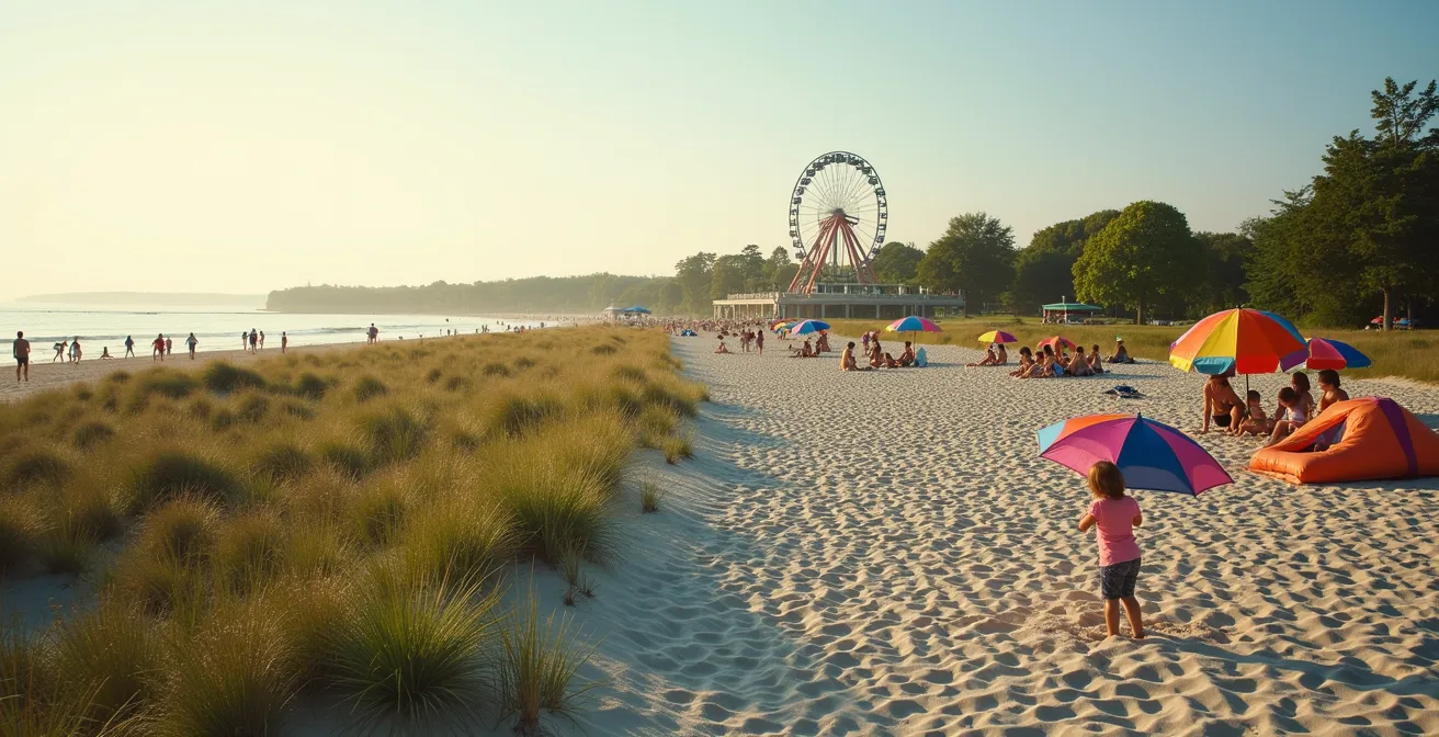
Centre Island Beach is the family-friendly, bustling hub. It’s the most accessible from the main ferry dock and is right next to the Centreville Amusement Park. The atmosphere is lively and conventional, filled with the sounds of children playing, families picnicking, and groups of friends enjoying a classic day at the beach. You’ll see colourful umbrellas, sandcastles, and lots of activity. It’s a safe, predictable, and fun environment perfect for those with kids or anyone looking for a traditional beach day vibe.
Hanlan’s Point Beach, at the western tip of the islands, offers a completely different experience. It is famous for being one of only two officially recognized clothing-optional beaches in Canada. The vibe here is significantly more relaxed, adult-oriented, and focused on quiet recreation and personal freedom. While one section is clothing-optional, the entire area is known for its accepting and respectful atmosphere. It’s a place of quiet solitude, with natural dunes and tall grasses offering more privacy than the wide-open spaces of Centre Island. It is the destination for those seeking to escape the crowds and enjoy a more natural, judgment-free environment.
Ultimately, the choice is simple. If you’re planning a day with the kids or prefer a lively, traditional beach scene, head to Centre Island. If you are seeking tranquility, a judgment-free zone, and are comfortable with or curious about the clothing-optional environment, Hanlan’s Point is your sanctuary. Knowing this distinction is key to a comfortable and respectful visit for everyone.
High Park vs. Trinity Bellwoods: Which Park Is Better for Picnics?
When the sun is out in Toronto, two parks become the epicentres of picnic culture: High Park and Trinity Bellwoods. While both are fantastic green spaces, they offer vastly different picnic experiences. Your choice depends on whether you’re seeking a quiet communion with nature or a vibrant social scene. A crucial new factor in this decision is the city’s Alcohol in Parks Pilot Program, which has changed the rules for picnickers in recent seasons.
As of 2024, the pilot program allows responsible drinking in designated areas of certain parks, including Trinity Bellwoods. This means you can legally enjoy a beer or a glass of wine with your meal, provided you follow the rules (like no glass containers and having food). It’s vital to check the City of Toronto’s website for the latest list of participating parks and regulations, as these can change. This program has further cemented Trinity Bellwoods’ reputation as the city’s social backyard.
A picnic at Trinity Bellwoods is a public affair. You’re there to see and be seen, spread out on a blanket amidst groups of friends, slackliners, and musicians. The energy is young, urban, and social. It’s perfect for a get-together with friends. High Park, by contrast, is a massive expanse of nature offering countless secluded spots. You can find a quiet corner by Grenadier Pond, a clearing in the woods, or a spot in the formal gardens. It’s the choice for a peaceful, romantic picnic or a family outing where you want space to explore. One important health consideration for High Park, however, is the presence of black-legged ticks in its more naturalized, wooded areas, so it’s wise to stick to maintained lawns or take precautions.
To help you choose, here’s a quick comparison of what to expect from each park for your next picnic outing. The data is based on general park features and accessibility from the waterfront.
| Feature | High Park | Trinity Bellwoods |
|---|---|---|
| Size | 400 acres with trails | 36 acres urban park |
| Waterfront Access | Bike ride to Sunnyside Beach | 509 streetcar to central waterfront |
| Atmosphere | Quiet, secluded spots near Grenadier Pond | Social scene with slackliners and music |
| Health Consideration | Black-legged ticks in naturalized areas | Safer, maintained lawns |
| Best For | Nature lovers seeking solitude | Social picnickers, see and be seen |
Key Takeaways
- Water safety is more than a website; always check for visual signs like murky water, especially after heavy rain, due to the 24-hour lag in official testing.
- Mastering waterfront logistics is key to a good day. A cheap ferry ride might cost you hours in line, while a water taxi buys you time for more enjoyment.
- Every beach and park has a distinct personality. Choose Woodbine for action, Bluffer’s for awe, Trinity for social scenes, and High Park for solitude.
- The winter shoreline is deceptively dangerous. Never walk on shelf ice, as it can collapse without warning over frigid water.
How to Navigate Toronto Islands Logistics for a Stress-Free Day?
You’ve checked the water quality, picked your beach, and packed your picnic. The final piece of the puzzle for a perfect waterfront day is mastering the logistics. A poorly planned trip to the Toronto Islands can quickly turn a relaxing escape into a stressful ordeal of long lines and tired feet. As a local, knowing the ins and outs of getting there and getting around is the ultimate key to a genuinely stress-free day.
The first hurdle is the ferry. While booking tickets online lets you skip the ticket-buying line, it does not let you skip the boarding queue, which can snake all the way through the terminal park on a busy day. Remember that the Ward’s Island ferry runs year-round, while the Centre Island and Hanlan’s Point routes are typically seasonal. A pro tip is to take the less crowded Ward’s Island ferry and enjoy the 25-minute scenic walk to Centre Island.
Once on the island, be realistic about distances. The park is huge, and walking from one end to the other takes over an hour. If you have small children or limited mobility, renting a bike or a quadricycle near the Centre Island dock is a worthwhile investment. Always, always check the time of the last ferry back to the mainland upon arrival and set an alarm on your phone. Missing it could mean a long wait for an expensive water taxi. By anticipating these logistical challenges—the ferry queues, the walking distances, and the return trip—you transform the journey from a potential headache into a seamless part of the adventure.
Now that you’re armed with the knowledge to read the water, choose your ideal spot, and navigate the journey, you’re ready. It’s time to get out there. Plan your next local adventure with confidence, respect the water’s power, and enjoy the incredible natural resource we have right at our doorstep.